I’m interested in how people have constructed large macro-regions, i.e., ways of dividing up the world and categorizing spaces, and how these imagined communities of nations influence behaviour, especially business behaviour.
Most readers will be familiar with Samuel Huntington’s influential Clash of Civilizations thesis. Writing in the 1990s, Huntington identifies several large transnational regions or “civilizations” and then predicted the geopolitical conflict in the future would be between civilizations rather than traditional nation states. His book, which was translated into a number of languages, influenced how many people thought about International Relations during the War on Terror of the noughties. I’ve put a German map based on Huntington’s ideas below.

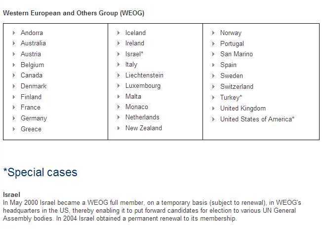
Interestingly, the US State Department and the US military use different macro-regions in thinking about the world and organizing their internal structures. It is well known that for much of the twentieth century, the US State Department assigned responsibility for relations with Australia and Canada to its Europe desk, even though neither country was in Europe. Australia was arguably an Asian country! This arrangement is a case of culture and ethnicity trumping geography. Even today, the allocation of nations to the various “Regional Groups” in the United Nations is informed by culture. Interestingly enough, Israel and Turkey have both joined the “Western European and Others Group” as so-called “Special Cases.”
In contrast, the US military’s command structure is more focused on just geography: the macro-regions it has created tend to be geographically contiguous rather than cultural-linguistic.
Map of the Unified Combatant Commands of the United States Military

I don’t know if the discrepancies between these two maps of the world has ever caused friction between the Defense Department and the State Department. Apparently, the US Defense Department is thinking of changing is system of commands.

P&G, the consumer products giant, has subsidiaries in many nations. The chemical subsidiaries are organized into three big regions. As this map shows, the regions ignore culture and contain countries are very different level of development. P&G’s system of regions also seems to divide the Russian Federation, which is fascinating. Mexico is defined as being part of “Latin America” rather than “North America,” even though automotive companies regard Mexico as part of a fairly integrated North American market.

Let’s turn now to the British Empire in the nineteenth century. Making maps and charts of the world’s lands and coasts was a big part of the project of Empire. To run a worldwide Empire, you have to know where things are. Technological advances such as a better chronometers allowed for more accurate maps and fewer shipwrecks. Culture also influenced the macro-regions that the British imperial state created. Scientists shaped contemporaries’ thinking about the world’s “natural” regions the British imperial state had developed in the early nineteenth century.
As other historians have shown, the criteria used by the British in the 1840s and 1850s to determine which colonies were worthy of Responsible Government were largely and explicitly racial,although climate was also a factor.[1] In the 1840s, the British adopted a highly liberal policy towards the colonies of white settlement in the temperate zones, such as Canada and Australia, granting these colonies self-government and constitutions that were essentially replicas of the British political system. The British even said that if one of these colonies wanted to declare independence, they could do so with the blessing of the British parliament. At the same time, people in the tropical colonies who challenged Britain’s authoritarian rule were brutally suppressed.
It might be said that the British state thought of its Empire as consisting of three macro-geographical zones: India; the tropical British colonies; and then the self-governing Dominions in the tropics.
The curious thing is that the Royal Navy essentially ignored these racial and cultural boundaries in establishing its own system for categorizing overseas British possessions. The Royal Navy divided the world into zones called stations. In 1818, the West Indies Station was merged with the North American one. The boundaries of this station remained unchanged until 1956, despite massive changes in naval technology, such as the shift from sail to steam. What is especially curious is that the North American/West Indies station included British colonies of both types: white majority colonies such as Nova Scotia and tropic colonies such as Jamaica.

I don’t know if anyone has explored the issue of the discrepancy between the RN’s system of thinking about regions and the system implicit in the Colonial Office’s decisions about which British colonies were worthy of Responsible Government.
Today, Ford organizes the world into four main regional markets: North America, South America, Europe, and “Asia-Pacific and Africa”. (See screen grab below). In the first half of the twentieth century, there were three regions. As Mira Wilkins has shown, the Ford Motor Company of Michigan was responsible for the United States and any countries in the developing world that weren’t part of the British Empire. Ford Ltd., in the UK was responsible for all of Europe and the British colonies in the Mediterranean. The Ford Motor Company was responsible for sales in Canada and all parts of the British Empire that weren’t in Europe, a truly massive area. The reasons for this arrangement are explained by Mira Wilkins.

Anyway, I would be interested in suggestions for further reading about how Multinational Corporations categorize nations. I doubt that many companies have ever use P&G’s rather crude system of dividing up the world. That system seems oblivious to culture, even though culture is so central to marketing products such as deodorants. Moreover, as a business historian, I’ve very interested in how MNCs imagined maps of the world have evolved over time. I might be wrong, I don’t think that much has been published on this topic. Any suggestions for reading would be appreciated.
[1] Catherine Hall, Keith McClelland and Jane Rendall, Defining the Victorian Nation: Class, Race, Gender and the British Reform Act of 1867 (Cambridge: Cambridge University Press, 2000), 179-80.

Leave a comment